panoramas of annapurna circuit.
'thorong la success?' tour
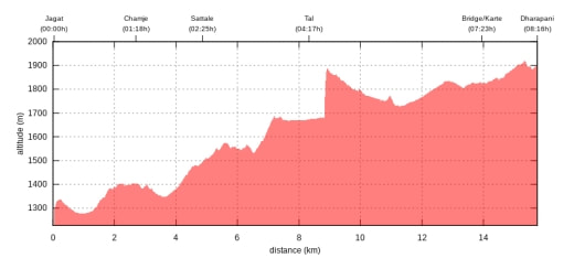
ngadi (930m) - jagat (1300m), 15km
reaching ngadi at sunset after one of these typical rides in a luxury chicken bus (in that case chicken is meant literally. i girl brought a chicken on the bus, never seen somebody being able to make a chicken fall asleep in her arms though. luxury is not meant literally though: it just means you have a reserved seat): bollywood-style videos with the classical blaring sound (earplugs helped not go to insane), central-european knees getting to know nepalese backrests, permanent honking while passing cars or while not passing cars. travelling business as usual.
guesthouse in ngadi with expected rustic charm, the food is freshly cooked and served by the owner's daughter with the outmost politeness and the sweetest smile.
weather close to perfect, a bit cloudy and hazy but dry.
warming up: leisure walk from village to village through the green landscape without much ascent, people are busy with harvesting rice. food and accommodation won't be a problem on the circuit. every village has at least one teashop and a guesthouse.
coffee with a view in jagat. starting my food routine for the next days: pot of ginger tea, soup, fried noodles and veg omelette. heat, liquid and calories...

jagat (1300m) - dharapani (1860m), 15km
starting the hike on the gravel road through the narrow valley. some villages and settlements on the way, various waterfalls, not exciting enough to take pictures but entertaining enough for the walk. after a while continuing on the trail. our speed is more than relaxing, it's unexpectedly warm but the occasional shade keeps it endurable.
info from jonathan, an american anthropologist and linguist who's doing work to preserve local nepalese dialects in the valleys around manang: the villages in this area are a result of e.g. forced migration of animists after the introduction of buddhism, flight of couples who's marriage were not accepted or simply modern tourism.
elaborate hot shower in dharapani (combined with the run to the room to get warm clothes). i fear that will be a luxury in the upcoming days.
meet brot, an american who was part of the team that set up the annapurna circuit in the 70s. he's doing research for an article for yale on the consequences of the increasing construction of roads in the himalayas (link) - a topic i will experience personally more than desired: increase of jeep tourism, less maintenance of the trail (competing with necessary road maintenance after landslides), guides using roads instead of the original trail...
i can't really complain about meeting boring people on this trip, can i!
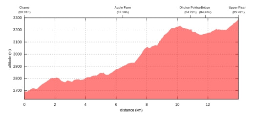
dharapani (1860m) - chame (2670m), 15km
trail and road alternating, road is blocked after a land slide, ascending through the forest, lunch break in timang with a quick look at manaslu mt before the rain starts for the next 3 hours. at least we're dry and there's plenty of food in the guesthouse.

chame (2670m) - lower pisang (3250m), 15km
cappuccino break at an apple orchard. have one of these road-or-trail-discussions with my porter. trail wins. the dusty roads are just a pain in the neck - to say the least. wasn't hiking something about nature? who would prefer to eat dust?
lower pisang (3250m) - ngawal (3660m), 10km
1st time to use cap and gloves. perfect weather, perfect photo stop at a lake. steep ascend on serpentines. it's irritiating: no soar muscles, not out of breath. strange. lunch break with awesome view of some annapurna summits (can't keep all the different annapurnas apart).
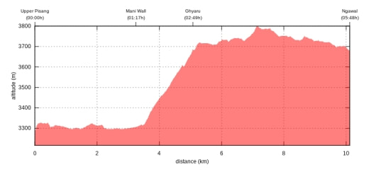
ngawal (3660m) - manang (3520m), 10km
cloudy, after breakfast another hour in the sleeping bag. no rush today. visibility can only get better with the rising sun. descending on a dusty road to manang. cloudy and grey but it has its own atmosphere. manang: smaller than expected but plenty of cappuccino and cakes.
day 1, bad weather day. equals sleep, food and cappuccino. checking weather conditions at the acap office. oxygen measure: 99%, pretty good value for this altitude, acclimatisation looks alright, i guess.
day 2, lazy day: waking up at 6am. sunshine! jumping out of the sleeping bag, as much as temperature allows, putting on some cloths over the pyjama. no time to waste, proper clothes can be organized late. the mountains are shining in the early light. some panorama pics, camera has a problem. maybe to cold or the chip is broken.
hike through the fields above the valley with fantastic views. summary of the day: a few thousand pics.
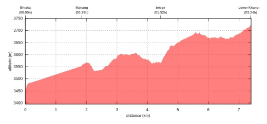
manang (3520m) - shreekharka (4000m)
steep ascend from village to village. not too bad. afternoon: sitting in the sun, staring at a mountain.
miserable night: no sleep.
shreekharka (4000m) - tilicho lake base camp (4140m), 9km
hiking along a narrow trail partly along a scree slope above the river. not really my preferred terrain. shortly before the base camp serious gusts of wind. l'm terminating the hike. raj my porter does not understand. well, i don't care about other people's opinion, not much to explain anyway, if you almost fell down a mountain once there's little desire to repeat that. certainly not for a few pictures or to follow the herd. i probably missed out on some perfect views but it's always about returning...
raj is obviously not used to such a behaviour: 'tilicho no success, thorong la success?' depends on your definition of success. he seems to worry about me not crossing the pass. well, if he knew that i returned some meters below kilimanjaro summit due to bad weather conditions he would probably shake his head even more.
spend the afternoon in the sun looking at an already known panorama.
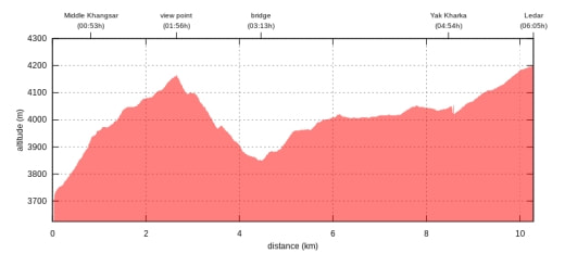
shreekharka (4000m) - ledar (4200m), 12km
turns out to be my favourite day. colourful scrubland, grazing horses on the fields, perfect viewpoint above manang with too many selfying people and the sun shining from exactly the wrong direction. optimizing my sun tan during lunch beak and in churi ledar.
first headache in the evening. diamox, ibuprofen and 2 litres of tea might do the job. symptoms disappear during the night. but no sleep again.
interesting indeed: no lack of appetitte, no muscle problems, no exhaustion, no breathing problems in the altitude. but no sleep.
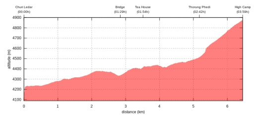
ledar (4200m) - high camp (4900m), 7km
headache is gone. ascent through landsclide area. always paying attention to the typical light noise of bouncing litte stones. after lunch steep ascent to the high camp. slowly, step by step.
and then it happens: 'click! click! clack! clack! clack!....' i just turn my had for confirmation for a split second: stones flying towards us. 'run!'
so we run. we're lucky: about 20 meters ahead of us is a huge rock where we find shelter, interesting to find out how fast one can run in this altitude. there are times when things must work. it wasn't a huge slide to honest. but i admit, no need to experience that life and in action.
we're reaching the high camp. luckily little wind. don't want to be here in bad weather.
sitting on the hill next to the camp and looking at the mountains around us. it's already a certain challenge to do a hike in 5000 meters in good weather. but climbing in 8000 meters with bad weather? beyond my understanding.
extra dinner before the ascent to the pass tomorrow: greasy pizza, fried noodle and lots of tea. as always: heat, calories, liquid...
funny alternating seat-around-the-oven-system: people are moving towards the only oven in the rooms. if your're next to the oven it gets to hot and your clothes might melt, so after a while you escape from the heat, if you're 3 meters away the oven doesn't really has an effect. so there's a permanent movement...
another sleepless night with a lot of coughing from the dry air.
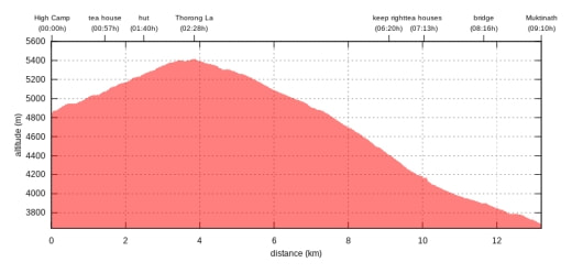
high camp (4900m) - thorong la (5416m) - muktinath (3670m), 14km
breakfast at 5am. not exactly my 9am espresso routine. trying to swallow some calories.
ascent in the dark is exhausting, not from the altitude but from the lack of sleep. a bit of snow on the ground and light snowfall but the ground is not icy and the weather seems alright. i wonder how the conditions are further up.
sunrise. the landscape is not a true highlight: windswept, barren, bleak,
arriving at the pass: not much to see. some panoramas and a jump picture (my nieces are demanding to keep the tradition alive).
descent is easier than expected. no abyss, no steep slippery path, no ice.
first view into the dry lower mustang valley.
on the way down i meet a guy from denmark coming up from muktinath. with a heavy bike. and his gear. just to explain: it's a steep 1000m ascend to the pass with no teahouses to rest. crazy stuff.
muktinath (3670m)
lazy day. for some reasons i'm exhausted. dragging myself out of bed for a cappuccino at lunch time.
muktinath temple in the afternoon: a sacred place for buddhists and hindus.
it's a cold and windy day. but that doesn't stop the pilgrims to run through the ice cold water coming from the holy fountains. that's what i call belief.
muktinath (3670) - kagbeni (2830m), 12km
grey and colourless day. a pity. deserts look better in sunshine too. well, better than rain.
passing the villages chongur and jhong on the way to kagbeni. looks like a rough life to me.
kagbeni (2830m) - marpha (2700m), 16km
way to jomsom is a disaster. landscape along the river is no bad but walking on the dusty road is just a pain in the neck. jeeps and busses are passing. their fun seems to be getting as close as possible to people walking on the road. when the bus is coming you can see it, you can hear it, and you can breath it - NOT.
jomsom turns out be utterly boring. quick lunch and off to marpha. just the same terrible walk on the dusty road. i don't think i'll do more hiking from marpha. just too much dust.
arrival in marpha. finally a village that looks inviting.
checking out some guesthouses can be so much fun:
-'i'd like a room with a window and access to light' ...rooms can be very dark in this part of the world, so obvious demands must be expressed explicitly
the owner points to a window.
- 'window'
- 'aha! what's behind the window?' ...complete fulfillment of demand has to be tested and proved.
owner opens the curtain.
- 'light!'
there might be a slight difference of interpretation of the status quo: as far is i can see it is a wall half a meter away from the window reflecting the last bit of light that shines into the gap between the neighbouring houses.
after 3 more trails we find an excellent guesthouse with a flower garden, spacious dining room, good food, and a room with a window... and erin and jan, whom i've met a couple of times on the trail.
next morning i stroll through the narrow lanes of the village. luckily the ceremony in the monastery is still going on.
chanting, drumming, jingling, trumpeting... interesting to watch, especially the enthusiasm of one of the novices. could sit here for hours...
meet a group of french runners... crazy people: they run the annapurna circuit. run as in walk quickly quickly.
start to walk to tukuche, the next village down the valley. after 5 minutes i turn back. in the afternoon the wind picks up and blows the dust up the valley...right into my face. seems to be a regularity of this microclimate. i guess this is happening all the way along the valley towards tibet. maybe my original plan to hike in upper mustang at this time of the year would not have been so much fun, sometimes it's good if plans don't work out. instead i explore the area above the village.
marpha (2700m) - pokhara (1400m)
as there is no more interesting hiking to be expected i decide to take the bus to pokhara.
in the morning waiting for the bus. guess what: the frenchies are starting their run down the valley. not jogging, running.
during the bus ride i will spot some of them once a while on the road or on the trail on the opposite site of the valley.
bus passing them. them passing the bus. incredible: by the time we reach a village in the early afternoon who's sitting in front of a guesthouse drinking tea? les monsieurs!
chappeau!
the bus trip turns out to be a hell of a ride. more excitement then needed as far as i'm concerned. i have the seat next to the door which means clear view of the edge of the road and the river below. sometimes the bus is closer to the edge than where i would dare to stand. i'm calculating the probabilities: the driver is not doing this for the first time, the road will not collapse today... sometime i just close my eyes. there's things i don't want to see... i if i had known i would have taken the plane from jomsom. plane crashes are less likely than bus accidents in this are. as i learn from brot's article not just an assumption: '...Bus plunges and other vehicle accidents occur routinely in Nepal. In a recent three and a half month period, 538 deaths were recorded on Nepal’s roads, an average of five per day...'
finally we reach pokhara in the evening. annapurna circuit finished.
summary: some of it was good, some of it wasn't. perfect weather, perfect acclimatisation, perfect infrastructur. but just way too much hiking on dusty roads. next time i would pick an area less accessible.

source of profile pics:https://de.wikivoyage.org/wiki/Annapurna_Circuit

